~ This post is only available in English ~
Flood regulation supply
Flood regulation supply is an ecosystem service, which, based on biophysical characteristics of the landscape, supports the mitigation of river floods. The effect of several biophysical factors on the indicator, i.e. land use, precipitation characteristics, type of the river catchment, water holding capacity of the soil, and location, were tested in experiments conducted in the hydrological model STREAM (Aerts, 1999). In each of the selected test catchments, it was tested how the variables affect the runoff volume at the catchment outlet after a rainfall event. The outcomes of the experiment were translated into a dimensionless index (0-1) and applied to Europe based on spatially explicit maps of the variables explored in the experiments, using a look-up table.
Flood regulation demand
For the demand indicator, downstream potential flood damages were quantified using the Damage Scanner model (DSM, Bubeck et al., 2011), which uses GDP, land cover, and inundation levels as a basis for estimation of direct flood damages. Flood damage was aggregated for each river catchment, and related to the available upstream area of the entire river basin. Thus, the higher the potential downstream damages, and the smaller the area to provide flood regulation upstream, the higher the demand for high flood regulation supply in the respective river catchment. Demands, expressed as an dimensionless indicator (0-1) are normalized across Europe using a min-max normalization.
The datasets have a spatial resolution of 1 x 1 km and reflect the reference year 2000.
– Institute for Environmental Studies, VU University Amsterdam, The Netherlands
– Soil Physics and Land Management Group, Wageningen University & Research, The Netherlands
– Water Insight, Wageningen, The Netherlands
Julia Stürck
For more information contact Julia Stürck (julia.sturck@vu.nl)
VU Amsterdam
Dr. Ate Poortinga
Wageningen University & Research
Prof. dr. ir. P.H. Verburg
VU Amsterdam
For this study, STREAM (Spatial Tools for River basins and Environment and Analysis of Management options) is used. This is a GIS based spatially distributed rainfall runoff model optimized for the analysis of the hydrological impact of land use and climate changes in large riverbasins (Aerts et al., 1999). The water balance is calculated per gridcell based on the Thornthwaite and Mather (1957) equation. In thisstudy, STREAM v1.1.3.1 was used.
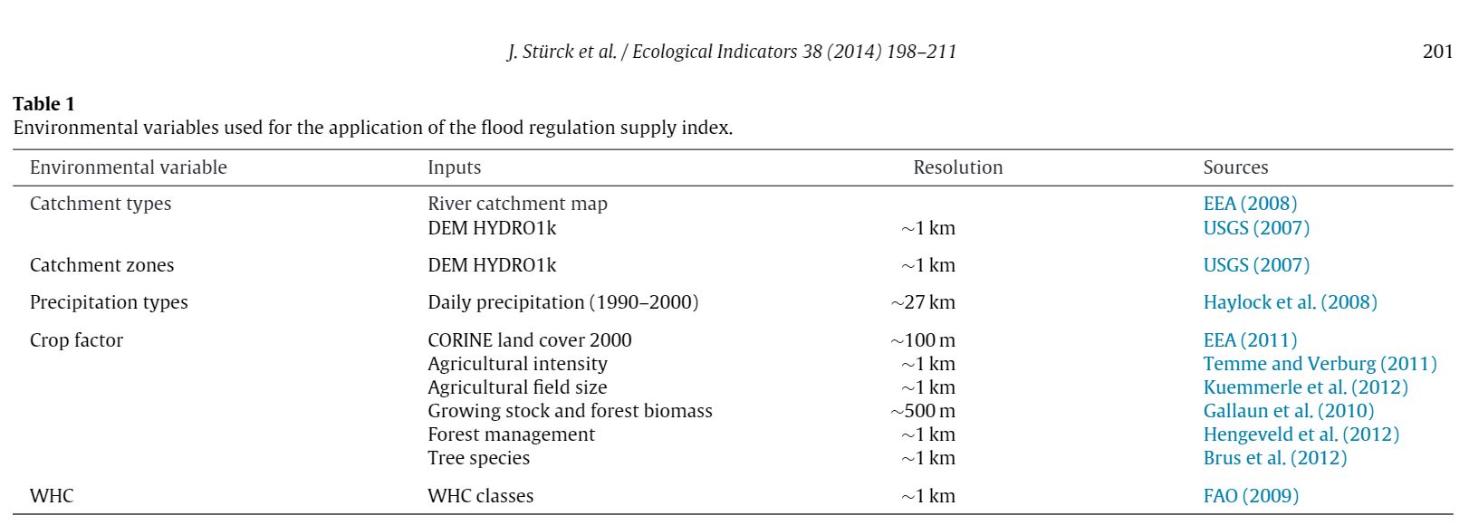
See this image for the datafiles used in this study.
Bij gebruik van de data refereert u naar:
Stürck, J., Poortinga, A., Verburg, P. H., 2014. Mapping ecosystem services: The supply and demand of flood regulation services in Europe. Ecol. Ind. 38, 198-211. http://dx.doi.org/10.1016/j.ecolind.2013.11.010